Saturday, October 29, 2011

OK, More Blogging (Including Bats)

At the time of writing this, I’m sitting just outside Male Airport waiting for my flight to Qatar, and sweating profusely. I took the 1 hour and 10 minute flight from Gan to Male that spans the entire western side of our northern balloon sounding array. The array very roughly forms a square and includes Colombo (Sri Lanka), Gan Island where I stayed for two weeks, Male, and a ship. The ship had been the R/V Revelle, but it has temporarily left its station. Hence, our sounding array has temporarily broken down. The flight was about 350 miles, and very roughly gives you an idea of how long our sounding arrays are on one side, although this distance is shorter than the distance between most stations in our two sounding arrays.

For much of my time on Addu Atoll, I was very disappointed that I could not get a good picture of the Addu Atoll Flying Foxes (bats). These things could carry off a small dog. Well, my luck changed while waiting at the airport for my flight. One fellow was sitting up in a fruit tree right outside the airport terminal, munching away.These bats are endangered just for this reason. They eat fruit (e.g. mangoes, papaya) and are hence killed by farmers protecting their crops. Most of my in-focus pictures feature the bat with a mouth full of food and hence the animal has a dopey and un-dignified look.

Here is a slightly out of focus picture without any eating involved. Now, doesn’t that look more dignified?

The Maldives are truly an amazing place. I took this picture on the plane to Male showing a few of the thousands of atolls making up the Maldives. The shapes of the landforms range from linear to donut-shaped, often with a deep abyss in the center. I snorkeled on my last day along the edge of the abyss that forms the center of Addu Atoll. It was a truly amazing experience.

A quiet day

Sunrise was at 0552 am at Hithadhoo today. No rain, a few isolated thunderstorms far away from the S-Pol site, our field office. This was a quiet day. Sunset was at 0555pm. 25 minutes before sunset, I left Container 9 beginning to ride the bike back from S-Pol to the resort. Today I started to use the bike that Eric left me. At the leaving time I took a picture of our container and the weather radar. Radar is obvious in the picture below. I labeled the Container 9 and lightning rods. Members of modeling groups, Smart-R people, and other visitors sit in Container 9.
Lighting rods are all around S-Pol. What's interesting is they are seldom used, because there are virtually no lightning since the beginning of DYNAMO. There are plenty of thunderstorm and rain, but no lightning. That's odd. Where is lightning? Look at the picture here:
This is a satellite image I borrowed from the DYNAMO data catlog. On top of this infrared satellite image of clouds are many purple plus signs; they are lightnings at 2am Oct 23. Plenty of them at Arabian Sea, but not at S-Pol, 0.59S, 73.1E. This is the typical situation of lightning over these days. Why this is happening is a mystery to me.

On my way back, I took another picture, 5 minutes ahead of sunset:
In a quiet day like this, we have little to expect from the radar screen. But chances to spot clouds are still plenty in a tropical island. 25 minutes after the sunset I got back in my room, in the dark.

Friday, October 28, 2011

Leaving the Maldives

I am leaving the Maldives tomorrow, and hence this will likely be my last post from the field. I leave with some bit of regret as I enjoyed the people of the Maldives as well as the enriching experience of being out in the field, but also feel that I leave with so much more to learn about the tropical atmosphere. I have gained a newfound appreciation of the complexity of the tropical atmosphere over the last couple of weeks, something that is difficult to gain from sitting at a desk in Fort Collins. Gust fronts propagate this way that blow up intense precipitation cells, upper level stratiform clouds move the opposite direction, dry air advects in from Africa and the Middle East in the west, and equatorial waves breeze through quickly, fundamentally altering the winds over the entire basin in the matter of a day or so. These are just some of the things I observed. I think that we also observed the initiation of a very interesting MJO event during my time here, and I experienced some of the heavy rains associated with this event. While we aren’t close to a complete understanding of how this event started in the Indian Ocean, we do know a few things so far. The central Indian Ocean near our observation array started out very dry in early October, and winds were generally from the west near the surface. At some point around October 10, the winds shifted rather abruptly to the east over much of the ocean. Accompanying this wind shift, moistening seemed to initiate on the equator first, and then soon was followed by moistening of the western Arabian Sea by east winds blowing moist air across India from the Bay of Bengal. We saw this moistening and shift in wind direction very nicely from the array of soundings we deployed during the project, and these will provide an invaluable resource to diagnose what precisely caused the moistening, in addition to model investigations we plan to do next. One other thing we realized during this project is that some of our commonly used indices used to diagnose the existence of the MJO may not perform well during all events. However, our understanding of what happened here is in its infancy. Tomorrow I leave on my 40+ hour adventure back to Fort Collins and reality. The Maldives will seem like a distant dream in a few days, I am sure. However, the DYNAMO field program is nowhere near over. My colleague Shuguang Wang arrived in the Maldives a couple of days ago to continue the experience of the modelers. Next, Adam Sobel and Zhiming Kuang arrive in November. They will likely experience many fascinating things on Addu Atoll and in the tropical atmosphere that are different from what I experienced here and will add to our fascination and understanding. This experience makes me want to come back to the field soon, as I feel that there are even more things that I need to learn. You may hear more from me in future blog posts, but these will likely be from behind my desk in Fort Collins or sitting on my living room couch (it was 3 degrees in Fort Collins last night! It will be quite the shock to the system to transition from our balmy 85 degree weather.)

Thursday, October 27, 2011

First 2 days at Gan ...

This is Shuguang Wang at Gan Island. I'm a member of the modeling group of the DYNAMO project. The right picture is me in my room at "equator village", the resort at Gan for most DYNAMO people. I use numerical models to study atmosphere for my research. I am here to appreciate how the tropical atmosphere is observed.
I arrived at Gan Island two days ago in the dark. My first day at Gan was Oct 26. I went to the S-Pol site, where there are ~15 people here. I worked in our field office "container 9". I also went to Smart-R site briefly with David and Jackson to pick up our food delivery. On the 2nd day here, I got sick and stayed in my room all the day. At the end of the day, I feel much better. I'm ready to explore tomorrow ...

Wednesday, October 26, 2011

It Rained, As Predicted.

It turned out that popcorn style convection that formed near the Addu Atoll amounted to nothing yesterday. Very quickly the cells formed anvils, the lower half of the clouds disappeared, and then a period of light rain from the remnant cloud tops occurred for a while, then petered out. We’ll get back to today’s weather shortly to see whether it followed the predicted two-day cycle.

First though, some bad news occurred at the end of the day yesterday. The Ka-radar band on the S-Polka radar used to detect clouds that are not heavily precipitating went kaput. It operated well for the first few weeks of the experiment, and then malfunctioned yesterday. It is still unknown what is wrong with the instrument and whether or not it can be fixed, but we are keeping our fingers crossed. You can see an NCAR radar technician working on the transmitter for the radar. Eventually, a crane came removed part of the instrument.

True to form, today was a very wet day with a large mesoscale convective complex over us, and we are still in this 2-day cycle of rainy day, dry day, rainy day, dry day, and so on. Jackson (graduate student from Monash) and I visited the Department of Energy’s AMIE site at the Gan airport that was described in a previous email by Daehyun. Sally McFarlane is showing us the total sky imager in this picture that is able to measure the fraction of sky covered by cloud. The technology consists of a convex mirror and a camera and is completely automated, replacing similar estimates made by weather observers. As you can see, the entire sky is overcast, and at this moment a light rain was falling. Most of the day stayed like this.

Jackson also got the opportunity to launch a balloon. Here he is being taught the correct technique for a balloon launch by a Maldivian meteorologist.

Precipitation really seems to be getting organized in the north Indian Ocean between the equator and 10 degrees north latitude. In particular, the pattern of winds and precipitation is looking more and more like a new MJO event is forming (to this scientist at least. There is still some debate in the DYNAMO community about this). I hope to blog on his in the next couple of days before my departure on Saturday.

However, look at what I am missing back in Fort Collins, Colorado. About 9 inches of snow, broken trees, and lower 20s for lows. I should try to enjoy the next couple of days while I can.

Tuesday, October 25, 2011

What A Difference A Day Makes

Take a look at this radar image from yesterday (top) at around 10 a.m., as compared to 10 a.m. today at the same time (bottom). At this time yesterday we were under a large precipitation shield hundreds of kilometers across associated with a “mesoscale convective system”. This precipitation shield is nicely shown from the S-Pol radar using the “centimeter wavelength” radar band that senses the presence of precipitation-sized particles including rain drops, snow, etc. Today, not much is going on.

The radar sends out radiating waves that have a trough and a crest and a trough about every 10 centimeters or so, which produces a return echo to the radar if a precipitation-sized particle is encountered. Birds and insects can also detected, and it has been noticed that sea birds tend to ride the leading edge of gust fronts generated by precipitation systems. The S-Pol allows beams of two different polarizations to be sent out, that allows both better sensing of precipitation, as well as determination of the types of particles encountered (e.g. hail vs. graupel vs. insects). S-Pol also includes a millimeter wavelength radar, which can sense smaller sized particles like drizzle and clouds droplets. I might talk about this instrument in a future post.

In addition to the S-Pol radar, we also have a precipitation radar at Addu Radar from Texas A&M called SMART-R, which is mounted on a truck and hence is more mobile. The wavelength for SMART-R is about 5 centimeters, which allows the radar to detect smaller particles (and also get blocked by smaller particles, so that you can’t see as well behind the clouds/precipitation detected). The SMART-R doesn’t do dual polarization.

Visual snapshots verify the vastly different cloud conditions between yesterday and today. The first image is from yesterday taken by the camera (facing east) on the S-Pol radar site. The second was taken by me this morning. The tropical field program veterans I’ve been talking to on this trip cite the tendency for there to be a 2-day cycle of precipitation in the tropics alternating between dry and wet days. It is hypothesized by these folks that a 2-day time period is necessary for the lower atmosphere (called the boundary layer) to recover from the previous precipitation event. This would imply that tomorrow will be wetter.

2:30 p.m addendum: Convection starting to develop like popcorn near us:

Monday, October 24, 2011

La Cucaracha

I had a visitor in my room this evening. I had to escort him outside. In addition to this fellow, I live with various geckos, toads, lizards, and mosquitoes.

Interesting weather today. It started out with a steady rain this morning as we were under a large “mesoscale” convective system. The sun was never close to coming out. The late afternoon featured a surge from the west that caused a brief period of gusty west winds but little precipitation. A stronger westerly flow exists to the west of us and extends to the coast of Africa. Will these winds come this way in earnest? We will see.

Saturday, October 22, 2011

The Trees and the Forest and Worms

Since I am a person who tends to takes a large-scale perspective on tropical meteorology (thousands of kilometers and greater), watching the radar all day and observing the small-scale features like clouds that are building blocks for large-scale tropical systems like that MJO has given me a very useful different perspective on the tropical atmosphere. I asked world renowned radar and tropical meteorologist Bob Houze whether there was anything interesting or new he has observed so far during DYNAMO that he has not seen in other regions of the tropics. One thing that was noticed in early October were what Bob termed “worms”. These were very narrow (~5 km diameter) convective features that formed upright vertically towers and poked up through very dry layers of the atmosphere. An example of such structure is shown in this vertical scan of radar reflectivity from October 3.

If we look at the sounding on October 3 (below), dry layers are noted near vertical pressure levels of 700 millibars and 400 millibars (1000 millibars is an approximate surface pressure at sea level in the tropics away from tropical cyclones, and pressure decreases upward away from the surface). However, these “worms” poked up through these dry layers. Typically convective clouds entrain (ingest) air from their environments, and if the environment is dry, evaporation/sublimation of cloud liquid water and ice within the rising cloud parcels cools the rising air, limiting how buoyant the clouds are. Clearly these worm clouds are not strongly feeling the dry environment and shooting right up through these dry layers, possibly indicating that entrainment is weak. The sounding also shows the wind profile in the vertical, indicating that there is very little wind at any height in the atmosphere until about 250 millibars is reached. This level is in the upper troposphere. The cloud top occurs somewhat above this level at 15 km above the surface. Maybe this lack of wind and associated wind shear through much of the troposphere is limiting entrainment? The atmosphere is also relatively unstable on this day, which would tend to foster greater buoyancy of convective air parcels and make them somewhat less sensitive to entrainment of dry air.

One thing I appreciate from watching the radar over the last week and zeroing in on a 150 km radius neighborhood around the radar is that it becomes very easy to lose a bigger picture perspective of what is going on in the Indian Ocean. While my previous posts have expressed some skepticism about the onset of a new MJO precipitation event in the DYNAMO observing region, it should not be forgotten that the Indian Ocean has undergone a dramatic moistening over the last couple of weeks, as can be seen by comparing these plots of vertically-integrated water vapor for October 9 and today. These plots show the amount of water vapor in the atmosphere summed from the surface to top of atmosphere. We hypothesize that a necessary condition for MJO convection to occur is growth of a deep moist layer in the Indian Ocean so that a dry atmosphere does not generally stifle deep MJO convective clouds. This large scale moistening we have observed should aid the growth of an MJO precipitation event. So maybe the conditions are primed for a nice event after all?

If this MJO precipitation initiation does indeed occur, an interesting question will be what generated this large-scale moistening of the Indian Ocean. If we can determine this, then we might have the keys to understanding MJO initiation.

A Walk About Town

In addition to writing that long post below, I also did a few other things today. For a change of scenery (and because a few of the radar people took the morning off), I moved my office for the day to a quiet corner of the hotel patio. Not a bad office.

At lunchtime, I walked about the neighborhoods on the island of Fedu to get a bite to eat and buy bread for my peanut butter and jelly sandwiches at the radar site (the radar site is relatively isolated from places to eat). Here is a shot of a typical street on Addu Atoll, featuring the crushed reef surface I mentioned in a previous post. Banana trees abound.

The typical houses consist of plastered cinder block or stone walls and metal roofs.

Some of the houses and yards are absolutely immaculate and I felt leery of walking too close so as to not disturb a rock on the sidewalk or knock a leaf off a tree.

I even came across the “Climate Change” store. It seemed to be raised up a few feet from the other buildings :).

Why MJO Initiation is Being Eagerly Anticipated

Much chatter has occurred over the last several days about the imminent blossoming of MJO precipitation in the Indian Ocean. One piece of supporting evidence for this sentiment is that if you look at the average evolution of MJO events over the historical record, they tend to follow a well-defined evolution of eastward-moving precipitation and wind patterns, and hence if we know the state of the MJO now, we might anticipate its evolution in the coming days based on past events. Statistical prediction models for MJO evolution have been developed using data from many past events.

The most widely-used measure to document the current state of the MJO is the monitoring method developed by Matthew Wheeler and Harry Hendon at the Australian Bureau of Meteorology. The diagnostics I will describe here can be found on Matt Wheeler’s website: http://cawcr.gov.au/staff/mwheeler/. How this method works is the following. If one takes the state of the atmosphere at the current time along the equator, at all longitudes from Africa eastward through the Pacific and South America and then onward to Africa, the pattern of upper and lower level east-west wind and precipitation anomalies associated with the MJO can be largely be explained by two dominant structures, as shown below (multiply the quantity OLR by negative one to get precpitation). We can think of “anomalies” as being the departure from some sort of long term average, much like a very cold night in the winter is often referred to by the weatherman as being “colder than average”. In this case, this would correspond to a negative anomaly.

With each of these structures (called empirical orthogonal functions, or EOFs), east-west wind anomalies in the upper troposphere (about jet aircraft cruising level, U200) are of opposite sign to those near the surface (U850), and enhanced precipitation occurs where low-level winds come together and upper level winds move apart. However, there are two such patterns displayed here, with the second pattern shifted eastward relative to the first one. This is because the MJO moves eastward with time, and therefore one pattern cannot always be the best match to what the MJO looks like at the current time. In fact, sometimes it is the combination of the two patterns that best matches the MJO at the current time, when the state of the MJO is transitioning between these two patterns.

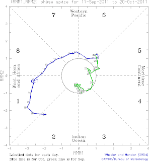
How the Wheeler and Hendon method documents the state of the MJO is to determine how well the current state of the tropical atmosphere looks like these two patterns associated with the MJO. If the atmospheric wind and precipitation anomalies are strong and greatly resemble one of these patterns (or the combination of them) at the current time, then the MJO can be said to be strong at the current time. A nice way of documenting the strength of the MJO is to plot a diagram showing how much the current state of the atmosphere resembles the first pattern (called RMM1 in the plot to the left) on the horizontal axis, and how much the atmosphere resembles the second pattern on the vertical axis (RMM2). If the strength of the signal is strong and the resemblance to the pattern is strong, then a high value of the RMM is reached. Since the MJO moves eastward, a typical MJO event will move counterclockwise around this diagram, progressing from positive RMM1 to positive RMM2 to negative RMM1 to negative RMM2. Why negative? It is just as reasonable for the atmospheric anomalies to resemble the opposite of the patterns shown above, and hence the RMMs can be negative.

This “phase diagram” shown here is nearly (but not quite) updated to the current day. The last day is October 20. Significant MJO events are typically defined as having a combined strength of RMM1 and RMM2 occurring outside the middle circle. In fact, the strength of the MJO has been well outside the middle circle for the past two weeks, and is near record strength at the current time. The phase diagram also shows geographical pointers indicating where the area of enhanced precipitation associated with the MJO was occurring at that time. The plot currently indicates enhanced MJO precipitation moving out of Africa and into the Indian Ocean. This has been the reason for all of the excitement over the last week, in that everyone is anticipating a blow-up of precipitation associated with the MJO in the DYNAMO observation area. Several statistical models also predict that MJO precipitation will blossom in the Indian Ocean.

However, not all measures are optimistic that this will occur. Numerous weather prediction models are run around the world that predict the state of the atmosphere out to several weeks from now. These models, while admittedly imperfect, include a relatively sophisticated representation of the physics of the atmosphere, albeit constrained by non-infinite computational resources, an imperfect knowledge of atmospheric physics, inherent limits of predictability of some aspects of the atmosphere, and other factors. Just as in the real atmosphere, we can use the structures shown above to document the strength and evolution of the MJO in the predicted atmosphere many days from now. Shown in the plot to the right is one prediction of the MJO for the next two weeks (relative to October 20) from the weather forecast model maintained by the NOAA National Centers for Environmental Prediction. Most models around the world demonstrate a similar prediction to what is shown here.

Basically, most models predict a plunge in MJO strength toward zero in the next week. Enhanced precipitation is anticipated to be relatively weak in these models in Indian Ocean, and with the lack of strong precipitation anomalies, the wind structure associated with the MJO cannot be maintained. Models do have a hard time predicting the initiation of the MJO in the Indian Ocean, and so these predictions should be taken with a grain of salt. However, over-exuberance for the imminent initiation of the MJO in the Indian Ocean is probably not warranted. Things could just as plausibly peter out.

On an unrelated note, here is a nice image of a rainbow taken last night on my bike ride back to the hotel. It was a beautiful night, with many people out and about on the street, because Friday is the local population’s holiday.

Thursday, October 20, 2011

Life on Addu Atoll

Rather than boring you with more minutiae related to the day’s weather, it might be nice to take a break and describe life on Addu Atoll. I have not been taking many pictures of atoll life yet (partially because I am always a bit nervous about taking pictures of people). But hopefully I will have ample opportunities in the next week or so.

A map of the atoll is posted in Daehyun’s October 15 post. The islands on the west side of the Atoll from Gan to Hitadoo are connected by a main road with occasional causeways over the channels between islands. My daily commute has recently involved riding a bike from Gan to Hitadoo where the S-Pol and SMART-R are located. On these trips, I have gained a greater appreciation of atoll life. The most pleasant part of the commute is getting off the main road and taking the side streets through the neighborhoods of Fedu and Maruda, where waving and smiling children are found all about who say “hi” and otherwise try to engage me in conversation. Some neighborhoods are surprisingly dense, with many blocks of one and occasional two-storey houses, mainly composed of cinder blocks with metal roofs. Except for the main street, most of the side streets are made of decomposed reef material (very much like the consistency of decomposed granite), and contain many potholes that quickly fill with water after the intense tropical rains. Tropical plants, large and small, mingle among the houses. I pass occasional stores in the neighborhoods, including salons, small grocers, and clothing stores. Islam is the only religion allowed in the atoll and I pass a mosque or two on my ride. The morning call to prayer near Equator Village usually wakes me up before 5 a.m. each morning (in addition to occasional tropical downpours thundering on the metal rooftop). Given the Islamic influence, most (but not all) women wear head coverings. As far as sports, soccer is big, and I have also seen volleyball and tennis being played at both schools and at parks.

Addu Atoll is not a wealthy area by any means, although some of the amenities of modern life in the developed world have penetrated into the Maldives, such as cellular communications (I am sending this from a cellular modem bought locally). Water is scarce in the Maldives. While some islands of the Maldives have desalinization capabilities, contaminated groundwater from septic tanks has led to severe water shortages. On Addu Atoll, enormous black rain barrels provided by the UN can be seen almost everywhere. This is the major means of drinking water for much of the Atoll, apparently.

One cool thing about the Maldives are the bats. There are two species of so-called “flying foxes” that are enormous fruit bats having a wingspan much like that of a red-tailed hawk or bald eagle. They even fly about during the day, and riding my bike through the neighborhoods having these enormous bats swooping about and soaring above is a fascinating experience. Apparently these bats are endangered in the Maldives because they destroy fruit orchards, and hence people concerned about their trees kill them. I don’t see that many birds, except for terns and intermittent other sea birds. There are geckos in my room!

However, not all is idyllic on the atoll, as trash seems to be a reasonably big issue. Since water is scarce, plastic bottles are relatively common, and so you see a concentration of these bottles in places you would prefer not, such as beaches and forests and along roadsides. A few of us have talked about possibly doing a small-scale clean up of some of the beaches near the S-Pol radar site.

I’m sure that I will relay more information on Maldives life in the next week, so stay tuned! I have yet to explore all parts of our portion of the Atoll.

Wednesday, October 19, 2011

A special, short two weeks

A special two weeks has been shortly passed. I’m writing this post in Doha international airport, where I’m on the way back home. After I got interested in tropical convection and modeling of it in my graduate school period, I have always been wished to attend a field experiment that aims to observe clouds. Simply I wanted to see what I’m trying to represent by thousands of lines of Fortran (a computer programing language) code, so that I could have some feelings about it. Sometimes I could see real clouds in the flight during travels, or from pictures of them. Apparently, they were not enough.

Since my arrival, the Gan Island has experienced a variety of atmospheric conditions from a very dry day, when I wished to see one cloud, to a wet day when I had to ride the bike through falling rain. During this period, I had been surrounded by a plenty of observations of cloud and the status of the atmosphere, stimulating scientific discussions about them, and, most importantly, the real tropical clouds that I could see by my eyes. After the special two weeks, I realize that I’m not as comfortable as I expected. This is because my current feeling about tropical convection tells me that modeling of tropical convection is much more challenging than I ever imagined. This means modeling and prediction of the MJO is challenging too because tropical convection plays a central role in the dynamics and physics of the MJO. Nonetheless, I found again that the tropical convection was so much fascinating to me that I couldn’t think of anything else. I’ll challenge.

I’m leaving, but I believe the DYNAMO scientists will continue the great work in the Gan Island, and other islands and ships in the Indian Ocean. Before I leave, I’d like to write names of some DYNAMO scientists. I’d like to thank Chuck, Paquita, Scott, and Courtney for their kind introductions to instruments. They were just great and it was truly fruitful. I’ll also try to remember the stimulating discussions with Brian, Paquita, Chidong, and Eric. Paquita, Courtney, Chidong and Chuck guided me to make a small contribution to DYNAMO field campaign, which I’m proud of. Finally, I appreciate my advisor Adam for his support on my special, short two weeks.

Tuesday, October 18, 2011

Not Yet Sure if MJO Precipitation is Coming

It was an interesting weather day today, as you can tell from the happy faces in Container 9….although we are still not sure if the MJO is coming.

The day started out with an interesting sky containing towering and building clouds off in the distance. One such complex of heavy precipitating clouds to the west of us set off an equatorial surge of west winds that blew through the Addu Atoll during the late morning/early afternoon and provided about a 20-25 mph flow from the west near the surface that decreased gradually through day. The layer of west winds was initially extremely shallow as noted by Doppler radar measurements from the S-Pol with a vertical wind shear of about 15 m/s or greater over the lowest 4 kilometers of the atmosphere. The shear could be clearly seen in the tilting of low-level clouds, as shown in the picture below.

A new area of convection developed to the east of us (likely initiated by this gust front) that provided much excitement and excellent photo opportunities, which Daehyun is taking advantage of in this picture.

Doppler radar showed that the layer of westerly winds mixed upward and deepened during the day, eventually weakening the westerly surface wind and turning the winds eastward near 4 km. The net result of the newly developed precipitation complex likely spawned by the gust front was an amorphous “stratiform” layer of clouds near sundown that lightly precipitated over the radar site, but also produced this nice rainbow as the sun set.

We are still not sure whether a new blowup of precipitation associated with the MJO is upon us. Although interesting tropical meteorology has been occurring in the Indian Ocean the last couple of days, the large organization of precipitation may be slightly less impressive today than yesterday. And dry air seems to be knocking on the door in the Southern Hemisphere. Are the hopes of an MJO precipitation event waning? Stay tuned I guess.

Monday, October 17, 2011

A visit to SMART-R site

Today, Eric and I visited SMART-R site. It is located in about 10 min. distance from S-Pol site by bike.
Here is an overview of the SMART-R site. The size of radar is smaller than that of S-PolKa radar. Although smaller, it covers more in vertical than S-PolKa by including higher elevation angles in their scans. There is no container, no lightening rod, and no toilet!
But we needed to pass fence with guard. The guard is sitting inside the small building.
The SMART-R is installed in a truck. When we visited SMART-R site, David from University of Miami and Jackson from Monash University were working there. David is wearing the 'DYNAMO t-shirt' and standing ahead of the truck.
Opposite side of the truck.

Jackson is giving a short introduction to the system to Eric inside the truck. Learning about radars is one of the reason why our trip to the Gan Island is so special for us!