Showing posts with label DYNAMO. Show all posts

Wednesday, October 19, 2011

A special, short two weeks

A special two weeks has been shortly passed. I’m writing this post in Doha international airport, where I’m on the way back home. After I got interested in tropical convection and modeling of it in my graduate school period, I have always been wished to attend a field experiment that aims to observe clouds. Simply I wanted to see what I’m trying to represent by thousands of lines of Fortran (a computer programing language) code, so that I could have some feelings about it. Sometimes I could see real clouds in the flight during travels, or from pictures of them. Apparently, they were not enough.

Since my arrival, the Gan Island has experienced a variety of atmospheric conditions from a very dry day, when I wished to see one cloud, to a wet day when I had to ride the bike through falling rain. During this period, I had been surrounded by a plenty of observations of cloud and the status of the atmosphere, stimulating scientific discussions about them, and, most importantly, the real tropical clouds that I could see by my eyes. After the special two weeks, I realize that I’m not as comfortable as I expected. This is because my current feeling about tropical convection tells me that modeling of tropical convection is much more challenging than I ever imagined. This means modeling and prediction of the MJO is challenging too because tropical convection plays a central role in the dynamics and physics of the MJO. Nonetheless, I found again that the tropical convection was so much fascinating to me that I couldn’t think of anything else. I’ll challenge.

I’m leaving, but I believe the DYNAMO scientists will continue the great work in the Gan Island, and other islands and ships in the Indian Ocean. Before I leave, I’d like to write names of some DYNAMO scientists. I’d like to thank Chuck, Paquita, Scott, and Courtney for their kind introductions to instruments. They were just great and it was truly fruitful. I’ll also try to remember the stimulating discussions with Brian, Paquita, Chidong, and Eric. Paquita, Courtney, Chidong and Chuck guided me to make a small contribution to DYNAMO field campaign, which I’m proud of. Finally, I appreciate my advisor Adam for his support on my special, short two weeks.

Tuesday, October 18, 2011

Not Yet Sure if MJO Precipitation is Coming

It was an interesting weather day today, as you can tell from the happy faces in Container 9….although we are still not sure if the MJO is coming.

The day started out with an interesting sky containing towering and building clouds off in the distance. One such complex of heavy precipitating clouds to the west of us set off an equatorial surge of west winds that blew through the Addu Atoll during the late morning/early afternoon and provided about a 20-25 mph flow from the west near the surface that decreased gradually through day. The layer of west winds was initially extremely shallow as noted by Doppler radar measurements from the S-Pol with a vertical wind shear of about 15 m/s or greater over the lowest 4 kilometers of the atmosphere. The shear could be clearly seen in the tilting of low-level clouds, as shown in the picture below.

A new area of convection developed to the east of us (likely initiated by this gust front) that provided much excitement and excellent photo opportunities, which Daehyun is taking advantage of in this picture.

Doppler radar showed that the layer of westerly winds mixed upward and deepened during the day, eventually weakening the westerly surface wind and turning the winds eastward near 4 km. The net result of the newly developed precipitation complex likely spawned by the gust front was an amorphous “stratiform” layer of clouds near sundown that lightly precipitated over the radar site, but also produced this nice rainbow as the sun set.

We are still not sure whether a new blowup of precipitation associated with the MJO is upon us. Although interesting tropical meteorology has been occurring in the Indian Ocean the last couple of days, the large organization of precipitation may be slightly less impressive today than yesterday. And dry air seems to be knocking on the door in the Southern Hemisphere. Are the hopes of an MJO precipitation event waning? Stay tuned I guess.

Monday, October 17, 2011

A visit to SMART-R site

Today, Eric and I visited SMART-R site. It is located in about 10 min. distance from S-Pol site by bike.
Here is an overview of the SMART-R site. The size of radar is smaller than that of S-PolKa radar. Although smaller, it covers more in vertical than S-PolKa by including higher elevation angles in their scans. There is no container, no lightening rod, and no toilet!
But we needed to pass fence with guard. The guard is sitting inside the small building.
The SMART-R is installed in a truck. When we visited SMART-R site, David from University of Miami and Jackson from Monash University were working there. David is wearing the 'DYNAMO t-shirt' and standing ahead of the truck.
Opposite side of the truck.

Jackson is giving a short introduction to the system to Eric inside the truck. Learning about radars is one of the reason why our trip to the Gan Island is so special for us!

Changing Weather

Today was a very different day than yesterday. No precipitation occurred (at least at the time of this post). The precipitation and deep clouds associated with the atmospheric wave of yesterday moved eastward, leaving us in the morning with layered mid to upper level clouds. These can be seen in this picture taken near the S-Pol site. The water and sand also look inviting!

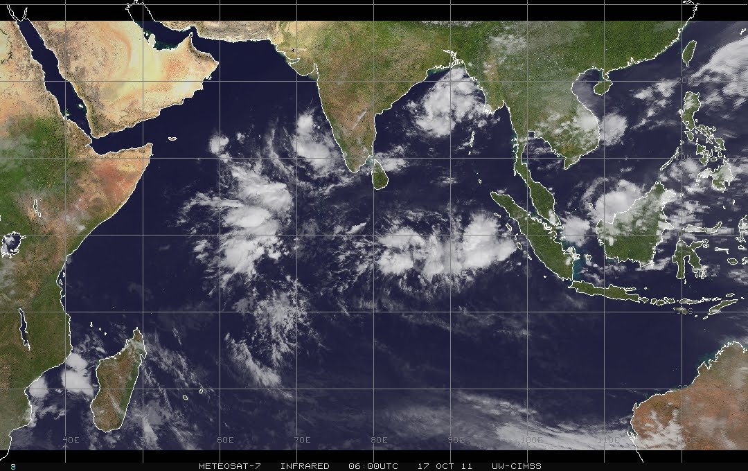
Much of the talk today involved the development of an area of precipitation and deep clouds to the west of us in the western Indian Ocean, which can be seen in this satellite image (an infrared satellite image for those in the know). This feature also seems to be accompanied by some rotation off the equator that is very intriguing. Is this the start of the MJO? If so, what confluence of events caused the development of this initial MJO precipitation area? If not, what else is responsible for this blowup of precipitation?

Some of the answers to these questions may become clear in the next several days, although the answers to the others may require years of study of DYNAMO observations and models. Regardless, the changing weather to the west provided some stunning scenes that made everyone wonder what we will wake up to tomorrow.

Sunday, October 16, 2011

A Rainy Day

I spent my first full day in the Maldives at the S-Polka radar site located about a 15 minute drive from our hotel near the airport। As Daehyun discussed above, S-Polka is an impressive radar! The day was uniformly gray with light to moderate “stratiform” precipitation and no sun, which we monitored all day on the S-Polka. The word on the street is that this may have been associated with the enhanced precipitation phase of a “convectively coupled equatorial Kelvin wave,” an atmospheric wave trapped near the equator that moves eastward, but at a faster speed than the MJO.

The working area of the S-Polka site consists of a series of equipped trailers where direct data feeds from not only the S-Polka, but other sites including the SMART-R radar can be accessed. Here is a shot of the crew in Container 9 today, including (front to back) Daehyun, John, Courtney, and Paquita. I was working to the left of Daehyun. Notice the dour looks because of the weather.

The S-Pol site even has a deluxe “throne” (Container 10), which is one of the nicer outhouses you will ever experience।

Saturday, October 15, 2011

A typical day

This is a map of Addu Atoll. The hotel where most DYNAMO scientists are staying is located in the Gan Island. The S-PolKa and SMART-R radars are in the Hitadoo, which is in northwest part of the map. The distance between hotel and S-PolKa radar is about 7km, and SMART-R is farther north than S-PolKa. I usually ride a bike to go there, but sometimes take a van.
This is the bike I use in a clear day to commute between hotel and radar sites. I brought it from New York City to here.
I found that it was a really good idea to bring it, which is Adam's idea. In rainy days, or if I'm too tired to ride a bike, the folding bike could take a car with me.
This is a typical scene when I get to the S-Pol site. It consists of radar facilities, containers that are used as offices (inside view of the containers is available below), toilet (see Eric's 'a rainy day' post), and some necessary ingredients that I'll introduce at the end of this post. The sky is somewhat different from what Eric showed in his 'a rainy day' post.
There is a signal of the S-PolKa radar.
In the following few pictures, I'd like show how hard are the DYNAMO scientists working.
Inside view on the container for National Center for Atmospheric Research (NCAR) scientists.
Scientists from University of Washington are working in another container.
There is a container for visiting scientists (the container 9 that Eric introduced). Here is where I'm working mostly.
Here are some non-scientific, but necessary ingredients of the S-Pol site.
A lightening rod protecting radar facility from any damage caused by lightening. There are several of them around the radar.
The radar site is secure: there is a team of guards (local people) working 24 hours. When I first came here and was taking a picture of the radar, they asked me what was my purpose and didn't allow me to approach to the radar. At that time, fortunately, I wore a 'DYNAMO' t-shirt and it helped me to convince him that I'm a related person.
Temperature here is around 28~32 degree Celsius in a clear day. Nothing is replaceable with an air conditioner in the tropics!

Hello, Maldives

Your second field correspondent has made it to the Maldives (but is very tired). I arrived in Male about 8 a.m. today, and immediately got immersed in DYNAMO. While Gan Island is the supersite for DYNAMO observations including the great density of atmospheric instruments that Daehyun has previously discussed, atmospheric balloon launches are also being conducted on Male, the capital of the Maldives. Male is in the northern Maldives, and Gan is across the equator in the far south. The Maldivian Meteorological Service (MMS) is only a 5 minute walk from the airport terminal in Male, an impressive modern facility.


At MMS, I visited Colorado State University graduate student Todd Jones, who is aiding in balloon launches during the early part of the DYNAMO experiment. While I was there, Todd and a colleague from Taiwan were trying to correct a problematic receiver that was causing the vertical profile of temperature, humidity, and other data from the balloons to be gappy. They set up a new receiver when I was there.


Look who got to launch the 10:30 a.m. balloon after all was fixed (wearing the same clothes I had been for 40+ hours). This is right before I got on my flight to Gan Island (where I will spend the next couple of weeks).


The DYNAMO scientists in Male have been complaining about the very dry and boring conditions in the northern part of the Maldives during DYNAMO, and have even actually been excited just to see an occasional cloud. Part of this boredom might be due to both the climatological position of tropical precipitation shifting south of the equator during October, and the suppressed phase of the MJO the Maldives have experienced during the last couple of weeks. We did see one cloud when I visited MMS (below). It appears to have formed over a smoke plume that was occurring due to brush clearing or some other man-made burning.

Friday, October 14, 2011

"इ'म गेत्तिंग तेरे"

After seeing Daehyun's latest post, I'm excited to get to the Maldives! I'm going to keep this short, since I'm having trouble keeping this entry posted in my native alphabet. I'm in Doha, Qatar, and After 22 hours of traveling so far, I don't look half bad, no? Only another 14 or so more to go.

A visit to AMF2 site

We are modelers in a field program. It is one of our goals to understand how the observation data we use is made. I'd like to share what I experienced in my visiting to the second ARM mobile facility (AMF2) site. AMF2 is a part of AMIE (ARM MJO investigation experiment) project, which is a brother field campaign with DYNAMO. Dr. Charles Long from Pacific Northwest National Laboratory kindly introduced all the instruments in AMF2 to DYNAMO scientists including me.
An overview of the AMF2 site.
Dr. Charles Long (right) is giving an introduction to instruments to DYNAMO scientists.
An observation tower that measures wind, radiative fluxes, rain, and others.
This total sky imager takes a picture of whole sky in every few seconds. So later on we know how much cloud was there on a certain day.
This microwave radiometer measures the amount of three phases of water, those are vapor, liquid, and ice, in the atmosphere.
I found there were two ways to measure surface shortwave radiation from Sun.
This machine measures direct and diffuse shortwave radiative fluxes in a modern(?) way.
This small crystal ball measures the strength of sunshine too, how is it possible?
The crystal ball concentrates sunlight into one point beneath it and it burns the paper under the ball. The paper is burned severely in a day of strong sunshine. Note that this instrument belongs to Maldivian Meteorological Service and is not a part of AMF2.
Guess what? This measures rain rate! In the inner hole, there are two cameras that take picture with very short time interval. When it rains, fingerprints of rain drops are in those pictures, and from that we know how dense the rain drops are as well as a size distribution of the drops.
After all introductions, it was a time to launch a radiosonde. In AMF2, people launch the radiosonde 8 times a day, so in every 3 hours. Luckily, I got a chance to do that and waiting for a sign to launch a radiosonde. The helmet is just for biking and not necessary for a person who launches a sonde.
The radiosonde is consist of a balloon and this part. It contains several instruments that measures atmospheric temperature, humidity, pressure. It also has a GPS receiver so that we could track the location of the sonde.

Tuesday, October 11, 2011

Getting Ready to Head Out

This is the first post from your loyal correspondent Eric Maloney. I am a faculty member in atmospheric science at Colorado State University, where I have been an Associate Professor for the last three years. The picture to the left shows my usual setting at a typical day at work. While I am a tropical meteorologist, as you can see, my work typically involves sitting in front of a computer screen in a land-locked midlatitude locale. People always ask me how I can possibly do tropical meteorology from a latitude near 40 degrees north (in addition to asking me what TV station I work for, or if I know Bill Gray). My response typically involves invocation of the wonders of technology (satellites, computer models, etc), but I always end with the lament that I have never done field work before, and wish that I could some day. Well, this is my first opportunity, and I am both excited and nervous about it. I will be leaving for Gan Island this coming Thursday October 13 to assist in DYNAMO. I will watch how observations of the tropical atmosphere are taken, assist in the taking such observations, aid in science discussions, and stay out of the way when my help isn't needed or wanted :). I hope to make regular posts in the Maldives to give the perspective of a modeler in the field, aiding in the endeavor also joined in this blog by my modeling colleagues Adam, Daehyun, Zhiming, and Shuguang. Now I need to get ready for that 36 hour travel experience starting Thursday!

Observing a precipitating cloud

The atmospheric environmental condition near the Gan Island has been generally dry since I came here. It is expected in such a dry condition that deep convection is suppressed. It is true and we couldn't see many precipitating deep clouds so far. It is not a good new for DYNAMO scientists here in Gan Island because they are waiting for a rainy period associated with the MJO starting. Even in such a dry condition, however, some spontaneous precipitating clouds have been observed. Here I'm going to share my observation of one precipitating clouds.

The S-PolKa radar in my previous post is observing clouds that are inside a circle centered at the radar location and has a 150km radius.

A precipitating clouds near the radar site was found from the radar reflectivity map. You could see it is located SE of the center. The smaller plot shows the vertical structure of the cloud through the yellow line in the large plot. Like this, one can look at horizontal and vertical structure of clouds using radar.

DYNAMO scientists came out of the container (office here) and were taking pictures of the cloud.

The precipitating cloud. You could see rains near the ocean surface.

A closure view on the near surface area. There is a clear distinction between clear and precipitating area.

In my normal like in NYC, I often watch radar maps to make my own forecast in a next couple of hours. But it was a really interesting experience to watch a precipitating cloud from the radar map and my eyes nearly at the same time!