Saturday, December 24, 2011

On a long-lived MJO event, and another Sri Lankan cyclone


We really seem right back in an active MJO phase in the Indian ocean.  Is it a new MJO event or did the old one never really leave as it was supposed to?  This comes down to a matter of what the MJO really is.  If it's something that goes eastward at a certain phase speed, then this is a new event.  But if we allow a little more flexibility - if we had a definition in terms of MJO dynamics rather than just statistical properties - then it's not so clear.  Maybe some MJO events just don't do so well at the propagating eastward part.

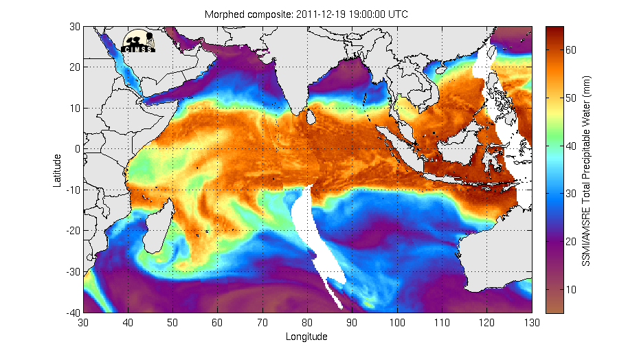
In any case, the satellite images from the water vapor IR channel of Meteosat as well as the MIMIC total column water vapor product both show the jellyfish structure, with the head of the jellyfish pushing up against Sumatra from the west:


The jellyfish is often a precursor to the formation of tropical cyclones.  Indeed the northern blob of clouds just east of Sri Lanka has been declared an "invest" by the JTWC.  Their current statement on the system says that the potential for the development of a significant tropical cyclone is "medium".  After my earlier experience, I now pay close attention to what happens here.  The Sri Lanka Meteorological Department does, to their credit, have a bad weather warning out on this system.  They politely say that "the fishing and naval community are kindly advised to refrain from their activities" in the region of the storm.  They do not, however, make any mention of the fact that there is a significant probability of this system becoming a proper tropical cyclone.  They have a specific area of their web page for cyclone warnings, which is currently blank.

As usual our information about what will happen in the future is in part based on numerical models.  Here is the 24-hour forecast of low-level (850 hPa) wind and relative humidity from the NOAA GFS model, valid 12Z Christmas day.  Note the swirling winds just east of Sri Lanka:
  
Also note the consistency with the GFS run of a few days ago shown in the previous post (valid the preceding day, today).  I didn't talk about this Sri Lankan system in that post but it was there in the model.  The consistency from run to run does remind me of the November storm.

I don't understand why the Sri Lankan forecasters (and as far as I can tell, the Indian ones as well - the IMD has no cyclone warning that I can find on this system either) think it would be so wrong to tell the public that there is a good chance a cyclone might form soon.  Surely they know that the potential is there;  they just seem not to want to use the word "cyclone" until one actually exists.  But that word gets people's attention more than just "bad weather" does, and is more likely to change people's actions.  Yes, there is a chance of over-warning, but isn't it better to take that risk if it could save lives?

Astute observers will notice that the GFS model is also still spinning up the sytem off the top end of Australia.  That system is not impressive yet, but JTWC statement on it rates its potential for becoming a significant cyclone within the next 24 hours as "high".  The Australian Bureau of Meteorology's forecast is here.  It isn't forecast to hit Darwin at this point, but still, the timing is spooky, for those who know Darwin's history with tropical cyclones.


Tuesday, December 20, 2011

The latest active phase cyclones

Tropical storm Washi formed around December 13, in the West Pacific (6N, 145E). At this point the MJO amplitude was weak. About a week earlier, though, the MJO had been quite strong - around 2 on the RMM scale - somewhere on the boundary between phase 4 and 5, which means active phase near the region of Washi's formation. This is pretty typical. The active MJO phase creates an environment favorable for tropical cyclone formation, but it often takes a few days or a week for the cyclones to actually get going. So the peak of cyclogenesis is not in the midst of the active phase, but a little later. It's fair to say that Washi probably owed its existence in part to the MJO.

Washi went on to do horrible damage on the island of Mindanao in the Philippines. The death toll now stands just below 1000. This is more than half the number of people who died in Hurricane Katrina. Yet this is not a story featured prominently in the news, at least here in the US.

In the meantime, at least some of the models are predicting a cyclone off the Top End of Australia, not far from the city of Darwin, in the next few days. Here's the GFS model's prediction of wind and relative humidity at 850 hPa (lower troposphere) for Christmas Eve:
The Australians living in this part of the Northern Territory have some experience with cyclones forming on Christmas Eve.

Monday, December 19, 2011

Can't let go

Here are the current Meteosat water vapor channel and MIMIC total precipitable water satellite images:
Looking at these, you might say that while by now the MJO should have moved on across the Pacific, it seems it hasn't; the center of convection seems to be somewhere in the Maritime Continent (aka Indonesia), with the eastern Indian ocean still being somewhat active, despite the title of my last post. The RMM index would agree with you. By that measure, the MJO continues to tool around somewhere between phase 4 and 5, unable to decide if it wants to move on east, go backwards, or die altogether:
Consistent with this the westerly wind anomalies are persisting - actually picking up again - over the Indian ocean:
And the recent soundings at Addu Atoll, such as the latest one, look not too far off what one would expect with the active phase - something like what we saw in the buildup. Not really busting loose, but not far from it. High humidity (consistent with the MIMIC picture), with dew point not much less than temperature, and healthy westerlies in the lower troposphere: Why can't the MJO make up its mind? What's going on?
This is not too uncommon really. In fact the spectacular behavior we had for the first two months of DYNAMO - with two healthy MJO cycles coming through like clockwork in two months - was somewhat unusual. What's interesting is that the forecast models reasonably well predicted this current slowdown (though perhaps the amplitude is staying a little stronger than predicted). What did they see? What atmospheric conditions cause the MJO to either move forward or stall, or to strengthen or die?

Wednesday, December 7, 2011

Dried out

The MJO has moved into phase 4 or even maybe 5 by now, with the active convection over the "Maritime Continent" (Indonesia) and making its way towards the Pacific. The Indian ocean has been suppressed for around a week now. Here's the current infrared satellite image:

There is some deep convection in the IO, but it's spotty. In the east, it's focused way in the southern hemisphere, in the form of two tropical cyclones. The eastern one has been named "Alenga", and is the stronger of the two (though still a tropical storm, below category 1 on the Saffir-Simpson scale used in the US), while the weaker western one has been dubbed, poetically "Two" - it will get a better name if it gets intense enough to deserve it. North of the equator, there is a well-defined but not particularly intense ITCZ in the west, off the east African coast. The northeast quadrant is pretty quiet up until Sumatra. Convection in the Bay of Bengal and Arabian Sea has completely shut down, perhaps for the season as we head into northern winter and the sea surface temperatures there are cooling rapidly. The southeastern IO is also completely dry. This can't be ascribed to the season, but perhaps can be blamed in part on the suppressed phase of the MJO.

A lot of us working on DYNAMO have become fond of the "morphed" precipitable water product called "MIMIC" produced at the University of Wisconsin. This is a product based on passive microwave satellite observations. ("Passive" means that the radiation measured is just what's naturally emitted from the planet, as opposed to e.g. a radar that sends out its own signal; "microwave" refers to the low frequency of the radiation measured.) The quantity shown is total column-integrated water vapor. That is, if you took all the water vapor in the atmosphere overhead at any given point and condensed it to liquid, this is how deep a layer of liquid water it would make. If the whole column were saturated - 100% relative humidity from the surface into the stratosphere - this depth would be a little over 70 mm, typically, in the tropics. (This maximum saturation value depends on the temperature, and so is less at higher latitudes.) Not much water in the atmosphere, right?

In any case, the atmosphere is never completely saturated, so the values you see are less everywhere than 70 mm (see the color scale on the right) though they get close in some places. A couple interesting things to notice in this picture:

1. The two tropical cyclones, Alenga and Two, show up as round red blobs swirling gracefully in the south, wrapping dry air around them on their western flanks.

2. The tongue of yellow and green pushing into the orange and red area - just south of the equator in the western IO, and extending about as far east 80E, roughly parallel with the tip of India. This is dry subtropical and continental air that has been pulled in by low-level westerlies associated in part with the late active and early suppressed phases of the MJO. It seems that the active phase to some extent puts an end to itself because the convection causes the westerlies (by fluid dynamics I'm not explaining today) but then the westerlies bring in dry air which shuts down the convection.

Going briefly to the local picture, here is a recent radiosonde trace from Gan plotted as a "skew-T log-P diagram". This is a very strange graph used only by meteorologists. I will not explain it in detail today, we'll leave that for another post. For now I just want you to notice that the green and red traces are relatively far from each other for most of the way up. This means that the dew point is much less than the temperature, which means the relative humidity is low. Not that low really, by the standards of the earth as a whole - the column water vapor is 45 mm (4.5 cm) as shown in the inset plot on the upper right. Notice, incidentally, that this value derived from in situ balloon measurements is in pretty good agreement with the satellite-retrieved value. In the MIMIC picture above, look at 73E, 1S - the location of Addu Atoll - and notice the color is yellowish there, which is around 45 mm on the scale at the right.
45 mm of column water vapor would be a large value - a humid atmosphere - in some places, for example New York City in winter. But for Addu Atoll in November, this is a relatively low value, lower than any observed during the 17 days I was just there during the buildup and active phase.

Tuesday, November 29, 2011

Goodbye MJO, and Addu

This is my last morning in Addu Atoll, after a truly inspiring 17 days. I was here for the start of the active phase of the MJO, and it's leaving with me. This morning the sky is almost cloudless. I seem to have misplaced the cable to download photos off my camera, but luckily there's one automatically taking pictures on a regular basis at the S-Pol site. Here's what it shows now - it's not beautiful photography but it gives you the idea.

I realize now that I haven't put up photos of what the sky looked like during the active phase. Perhaps because it wasn't as striking as during the suppressed phase, when there were convective clouds but they were isolated and one could get a good view of them. The active phase tended to be overcast, and not as superficially glamorous. I'll put up some when I get back.

The active phase is still in the Indian ocean, but the focus of the convection has moved to the east and south of the Maldives, as the current infrared satellite image shows:

Notice TC 5 is still kicking around the northern Arabian sea, hanging on for dear life against strong vertical wind shear.

My colleagues who were here before me wrote a fair bit on the blog about the more human side of being in the Maldives. I haven't done that up to now, partly because they had done it already and partly because I wanted to focus on the science. But besides the science, it has also been wonderful for me to be a visitor here. While my interaction with the local people has not been particularly deep, I have spent two and a half weeks biking back and forth through their home towns every day, shopping for groceries, going to the bank, the Dhiraagu (cell phone & internet) shop, and laundry (the last is basically in a family residence, with kids running all over and clothes hanging on lines in the yard). Like everyone else who has come here for DYNAMO, I've found the people very open and friendly.

Addu Atoll is apparently - according to tourist guides - the one place in the Maldives (apart from the capital, Male', where no tourists spend any time) where it's easy for outsiders to be in local villages and interact with Maldivians who are not resort employees. You hear the calls to prayer, see everyone zipping around on their motorbikes, and witness other dimensions of life in this tiny island nation. I've seen a couple guys carrying a big octopus off the beach one morning (obviously it was about to become lunch), lots of people swimming in the afternoons (the women in full long pants, sleeves and hijabs) and a guy building a boat by the side of the road.

Quite a number of times random people have struck up conversations with me, asked where I'm from, and whether I'm on vacation. They are always a little surprised to hear "no", and their eyes widen a little more still when they hear the actual reason. As a New Yorker, I instinctively get a little edgy when a stranger starts to talk to me in an unfamiliar environment. Experience at home has taught me that usually it means they want money, or to get me to their bible study group, or some other purpose I want no part of. That instinct is misplaced here. People are just genuinely eager to meet foreign visitors and learn a little about us.

It's hard to get a decent cup of coffee or slice of pizza in Addu City, but apart from that it's a wonderful place. It's been a great privilege to be here for this brief time.

Monday, November 28, 2011

Fishermen died unnecessarily in Tropical Cyclone 5

In my post of a few days ago I wrote about a developing tropical cyclone near Sri Lanka. This storm has since developed and been named "Tropical Cyclone Five" by the Joint Typhoon Warning Center. It's not particularly intense as tropical cyclones go; if it were in the Atlantic we would say it was a "Tropical Storm". Still, that's enough to be dangerous if you sail a boat into it. Unfortunately, a number of Sri Lankan fishermen have died - exactly how many is not clear yet, but the media are reporting 20 deaths and 43 missing - apparently because they did just that. Here is a recent story about it.

Had these fishermen known there was a serious storm there, presumably they might have stayed home. Almost certainly they did not know, because no forecast of this system was issued in Sri Lanka. Apparently Sri Lankans realize that they deserve better; a government inquiry has been launched into why their Department of Meteorology didn't predict TC 5.

Sometimes tropical cyclone formation is very difficult to predict. But as science improves year by year, we get better at it as our tools for doing it improve. The real tragedy of TC 5 is that it seems to have been unusually predictable, given the tools we - the international scientific community -currently have and were actually using in the lead-up to the storm's development.

We here in the Maldives working on the DYNAMO project are continuously looking at numerical model forecasts for the region. Some of these forecasts are being done specifically for the project, but most are the same ones that are done all the time by various operational weather centers around the world. They are being made a little more directly and easily accessible to us than they normally might be, but much of this information is routinely available on the web.

We saw TC 5 forming in some of the model forecasts around a week ahead of time, more or less simultaneous with the predicted onset of the active MJO phase in the Indian Ocean. This is a long way ahead to predict tropical cyclogenesis, so at first we weren't confident the models were right. However, as the week progressed, the picture became more and more convincing. The different models were agreeing with each other, and forecasts from the same model on different days also were very consistent.

Here is the forecast of relative humidity and wind at 850 hPa (around 1.5 km above the surface) for 06 UTC on November 25th. This is the GFS model, run by the US National Oceanic and Atmospheric Administration. The plot shown is made from a model run six days earlier. That is, it's a six-day forecast. Notice the swirling arrows right on the southern tip of India. That's the predicted TC 5. Sri Lanka is just to the southeast of the tip of India, well within the forecast storm.
Now here's a set of five more predictions, all valid at the same time (06 UTC on the 25th), but performed on successive days, getting closer and closer to the 25th. So the first one down is a five-day forecast, the next is a four-day forecast, etc. Keep your eyes on the tip of India - around 10N, 75E.
You can see the consistency in the forecasts. The predicted strength of the storm increased a bit in the later forecasts compared to the six-day one, but its position and timing didn't change much.

It seems to me that if forecasters in Sri Lanka had been looking closely at this model --- or others like it that showed more or less the same thing --- they couldn't have avoided thinking that there might be something here worth telling the public about. Even if one were disinclined to trust the models, the consistency of their message should draw one's attention. So I can only guess that they weren't looking at the models.

I was communicating by email with a colleague in Sri Lanka earlier in the week. On Tuesday I mentioned that the models were showing a TC developing, and on Wednesday the 23rd - as it looked more and more real - I asked him whether anyone there was paying attention to it (having looked on the web to see if any forecast had been issued, and seeing none). He called some contacts at the Department of Meteorology, and said that "they are expecting heavy rains on the eastern hill slopes but not a cyclone or storm - looks like they are only looking at the satellite images". In many cases tropical cyclones form far from shore and so one has time to see them develop in satellite images well before they form a threat to those on (or near) land. TC 5 formed close to shore so this method didn't work well - one needed the models.

Well, we - my Sri Lankan colleague and I - tried, in a very small way. In hindsight, maybe we could have tried to find some way to make a louder warning to someone who might have been able to do something. But neither of us is a forecaster by trade nor in any position of authority. Speaking for myself, I just couldn't quite believe it could be true that I had information that could save lives, but that no one else who knew as well or better was minding the store. Apparently that was exactly the case though. It wasn't my job, and I'm pretty sure I couldn't have done anything for those fishermen, but I can't help feeling that I could have.

Sunday, November 27, 2011

Blow, ye winds in the morning

The active phase continues to live up to our hopes. Today I focus on the weather this morning in Addu. Early this morning a strong, very coherent line of convective cells went through. Here it is on S-Pol reflectivity map for 0117 UTC (6:17 AM local time).
This line was moving roughly parallel to itself, that is, southwest to northeast, which was the way the wind was blowing at low levels.

When we went to work in the morning a little after 8, this line had broadened (or a new one had developed and merged with it) and when we got to the S-Pol site about 8:30 (0330 UTC), it was pouring very hard. The reflectivity map looked like this (S-Pol is at the center):
The wind was howling as well. To quantify this, here is a plot of doppler radar velocities measured along a cross-section pointing roughly east-northeast - that is, down the axis of the line. The x axis is range from the radar along that direction, the y axis is height, and the color gives the speed of the wind according to the color bar scale on the right, in meters per second. The radar measures only the component of the wind velocity towards or away from the radar. The strong red blob at the lower right of the plot tells you that the winds at the surface were greater than 20 m/s (~45 mph).
The strong decrease in wind speed as you move right from the low-level wind maximum around 20km range indicates very strong low-level convergence. Convergence is a technical term that means exactly what it sounds like - flow converging like water does when it goes down the drain. Just as in that case, where the water can't disappear so it has to be going somewhere in the third dimension (down the drain), in this case there is no drain so the flow has to be going up. This convergence is consistent with a very strong updraft.
The rain gauge at Gan (about 7 miles away from S-Pol) showed rain rates instantaneously above 100 millimeters per hour, which is pretty respectable. The accumulation for the event (not shown) was around 30 mm.
What was interesting about this is that the rain appears to have been mostly "stratiform" by which we mean, forming from thick continuous layer clouds that usually have modest updraft speeds, rather than intense convective cells with strong updrafts and less horizontal homogeneity. A classic indicator of the stratiform nature is the "bright band" apparent on this radar cross-section. This plot is similar to the one above of velocity, but it shows reflectivity instead, vs. range and height.
The bright band is the thin layer of high reflectivity around 4 km, which is just below the "melting level" - the level at which the atmospheric temperature is zero degrees C. At this point frozen hydrometeors (snow etc.) are melting as they fall. They reflect the radar beam very effectively for a short time until they melt more as they fall further into warmer air below. Commonly stratiform rain is lighter than convective, but clearly that needn't always be the case.

PS: For those of you who don't recognize the quote in the title of this post, try this. No marine mammals were harmed in the production of this blog.

Friday, November 25, 2011

Cyclone and westerly wind burst

As we get deeper into the active phase, the flow over the Indian ocean has come to be dominated by the developing tropical cyclone that is just north of the equator and east of the Maldives. In satellite imagery the clouds are beginning to have a hint of telltale swirl, but still the convection associated with this storm is not yet that well organized. Just looking at the latest Meteosat water vapor image for example, you might just say it looks like an active MJO event.
If you look at the low-level flow on the other hand - here in a very short-term forecast from the French Arpege model - you clearly see the circulation, just south of India. The colors in the image show geopotential at 850 hPa; think of this as a measure of the pressure field just a little ways above the surface. The blue indicates the center of the low pressure system.
The various operational weather centers that track tropical cyclones in this region are just now starting to take an active interest in this system. The US Navy's Joint Typhoon Warning Center's current warning says "THE POTENTIAL FOR THE DEVELOPMENT OF A SIGNIFICANT TROPICAL CYCLONE WITHIN THE NEXT 24 HOURS IS HIGH." The Chennai regional office of the India Meteorological department has a statement on their front page that reads "A well marked low has formed over Comorin area and neighbourhood on 25.11.11. Fishermen are advised not to venture into open sea along and off Kerala, Lakshadweep and South Tamil Nadu coast".
This is a very low latitude storm, with a center currently diagnosed at about 4 degrees latitude - much closer to the equator and tropical cyclone formation becomes more or less impossible. On the equator, or just south of it as here in Addu, it's hard to say to what extent the low-level westerly winds are associated with the cyclone, and to what extent they are part of the MJO westerly wind burst. Maybe the distinction isn't even meaningful. What's for sure is that the westerlies are strong. Yesterday the P3 flew in the area and dropped many "dropsondes" - basically similar to radiosondes, except instead of going up with a balloon, they are dropped from a plane. Here is one very near the equator south of the cyclone, showing westerlies as strong as 40 knots in a deep layer. (The picture below is a little too fuzzy, you can see a better version here.) Look at the wind barbs on the lower right; a long barb is 10kt, a short one is 5; you have to make an effort to read them as they are stacked very close together, indicating that the sonde made many measurements close together in height.
That's a westerly wind burst for you!

Wednesday, November 23, 2011

Active MJO!

If you have been reading this blog for a while, you know something about how to interpret the various kinds of images and graphs we use to interpret the state of the tropical atmosphere and the MJO in particular. So today I will just give a few pictures without too much explanation, to indicate what is going on. It's quite exciting at the moment and there is a lot to see as the observations roll in hour by hour, so I don't want to spend a lot of time blogging. The bottom line is that the MJO is here in the Indian ocean. Below is the RMM phase space plot again. It shows that we are in early phase 2; this plot is already a couple of days out of date and so most likely we are further into phase 2 at this point.
Here is the Meteosat infrared satellite image (water vapor channel) as of 0930 UTC today. Notice the strong and widespread equatorial convection.
Below is a map of the flow field (arrows) and relative humidity (colors) at a pressure level of 850 hPa, which is about 1.5 km above the ground. Notice the equatorial westerlies (arrows pointing to the right) and cyclonic gyres on both sides of the equator (counterclockwise is cyclonic in the northern hemisphere, clockwise is cyclonic in the south). This is what the flow looks like during an active MJO phase in the Indian ocean.
The circulation just south of Sri Lanka is actually forecast by some of the models to become a substantial tropical cyclone, which if true would likely make landfall in southern India in the next day or two. The one just northeast of Madagascar may become a tropical cyclone as well.

Now the local picture: it has been raining all day here in Addu. Here is what the S-Pol reflectivity map looks like as I write this:

Now for a change let's look at the time series of surface wind observations for today, below. The blue is wind direction, with the scale on the left, in degrees. So zero degrees is wind from the east, 90 is from the north, 180 is from the west, etc. Wind speed is on the right, in meters per second. So what this plot shows is that at about 730 UTC - 1230 local time in Addu - our winds spiked up and shifted from southwesterly closer to westerly. Since then we have had winds of 10-12 m/s, which is 22-25 mph. At least from this one island, on this one day, it looks and feels like a "westerly wind burst", which is a classic indication of the MJO active phase. The fact that it keeps pouring doesn't do anything to diminish one's impression that that's what's going on.

Monday, November 21, 2011

A balloon launch

Today, we (Tammy Weckwerth, Jean-Philllippe Duvel, Adam Sobel and I) had a tour of the ARM mobile facility with Liping Deng and launched a weather balloon with our signatures on it. ARM is the Atmospheric Radiation Measurement program (now part of the Atmospheric System Research program) of the Department of Energy. We were able to visually track the balloon as it rose to as far as 300hPa (~9km). It took more than half an hour and was quite remarkable: the balloon was reflective enough that it looked like a little star in the sky, and even twinkled a bit from time to time. I lost track of the balloon after 300hPa but Jean-Phillippe apparently could still see it...
We were able to check the data the balloon collected in real time as the balloon rose. The figure to the left is a screenshot that shows temperature (red), pressure (green), and relative humidity (blue) as a function of time (the vertical axis). Notice that the balloon rose more slowly after 900seconds, as seen in the change in the slopes of the temperature (red) and pressure (green) curves. The slowdown happened right after the balloon passed through a cloud (see the relative humidity curve). This seemed to indicate an icing problem. As the temperature is below zero Celsius, ice can stick to the balloon, weighing it down. Our balloon survived though, reaching at least 20hPa, as Liping told us later.That was OUR sonde, Nov. 21, 12UTC, from Gan Island.

Sunday, November 20, 2011

Gust fronts and dragonflies

Hi, this is Zhiming, the last of our modeling group to set foot on the Gan island.

I got here in the evening of Nov. 19th. It was a long flight but I slept reasonably well on the airplanes. And I was advised not to go to bed before 10pm to get over the jet lag sooner. So after dinner, I had a beer with the folks that were already here, Adam Sobel, Chidong Zhang, Jean Philippe Duvel, Deanna Hence, and Hannah Barnes. We talked about the interesting weathers that were going on, and Adam has been writing about these in other posts of this blog. In those conversations, I came across this idea about dragonflies giving the radar returns for gust fronts. "That sounds pretty exotic", I thought.

The next morning, I went to the S-Pol site. It is an impressive radar (see pictures in earlier posts). With 1 MWatt of power, 0.9 degree of beam width, and dual polarization, it can see a lot of things. Tammy Weckwerth, a NCAR scientist working with S-Pol, kindly showed me some of the data they have been collecting.

Here is a snapshot of the ZDR data from the radar (left figure below), where ZDR is the ratio of the returns in the two polarizations. It gives a measure of the aspect ratio of the objects that are scattering back the radar signal. Higher ZDR values tell us the objects are wide in the horizontal and short in the vertical. Such values are useful to tell apart different types of objects: for example, whether they are snow, hail, or raindrops.

This figure is 300km across in each direction. Note the red circles between 11 and 12 o'clocks and also between 6 and 8 o'clocks. It's a scan at 0.5 degree angle. At 50km radius, the radar is looking at roughly between the surface and 1km. These circular features were spawns by small showers.


"That's pretty cool", I said. The features also reminded me about pictures that I had seen like this one (right figure above) from NASA's Multi-angle Imaging SpectroRadiometer (MISR), where the cold pool expands and the gust fronts spawn new lines of convection.

The question now is what's giving the radar returns in the S-Pol image? Cloud droplets are nearly spherical and should have a ZDR close to zero.

"Dragonflies." said Tammy.

I didn't have too much beer the night before and as I said I slept pretty well during the flights. So I remembered this exotic idea from the conversations that I had the night before. Now I know where it came from.

I was intrigued. Swarms of dragonflies telling a radar scientist where the gust fronts are... This is not unusual over land where reflection off insects is common. But over the open ocean... Hmmm. "The ZDR is too high for cloud droplets and for clear sky turbulence", Tammy reasoned. " And "there is this annual migration of dragonflies from India to the Maldives and Africa and back", she quoted a recent paper, "the maximum numbers are here in November and December". Apparently, the dragonflies reproduce in fresh water pools whenever possible and it takes 4 generations for them to migrate. I would encourage you to contact Tammy to learn more about the dragonflies. And if you are an entomologist reading this blog (for whatever reason), you might be interested in knowing that the dragonflies might have helped Tammy to track the gust fronts.

It would be nice to actually see the swarms of dragonflies by eye. Tammy is still waiting to hear from the P3 crew on whether they saw the dragonflies when the plane flew through a gust front. It would also be interesting to see if this return signal from the radar becomes more rare when the migration season is over.

That was my first day at S-Pol. Among discussions of waveguide, beam width, extratropical intrusions and of course MJO initiations, was the story of dragonflies and gust fronts.

Oh, before I go, a couple pictures of rainbow in the rain shaft and the sunset.

Double ITCZ

Here's the current infrared satellite image (1130 UTC November 20). Remarkably symmetric double ITCZ structure - two long east-west lines of convection, one on either side of the equator. The cross-equatorial symmetry is more or less typical of this time of year, the transition season when the sun is moving from one hemisphere to the other. But I don't know that we get a double ITCZ this nice all so often in the Indian ocean.
But the two hemispheres are not as similar as they might seem. This image shows approximately the same piece of real estate as the one above, but superimposed on the IR image (which has a different color scale and perhaps infrared wavelength channel than that above) are pluses indicating lightning flashes. Why are there many in the north and none in the south? Some ideas have been batted around by the scientists here, but I will leave it to you to speculate for yourself. In the bigger picture, the flow in the last couple days is looking very reminiscent of the period in late October right before the start of the active MJO phase in the Indian ocean. In fact, the RMM diagram is in a similar phase to then as well. The latest date on this plot (thanks again Matt Wheeler) is Nov. 18, a couple days ago, and we were in mid-late phase 1 then:
By today we may be getting close indeed to phase 2. We may have our second MJO onset very soon!

Saturday, November 19, 2011

Clouds

Today I offer you no hard science, but just photos of clouds. There are lots of different species on perpetual display out here on Addu Atoll where the sea is always very close and the view tends to be unobstructed for a long way. But I am most fascinated by the precipitating cumuli. It was a pretty calm day here today, but there have been isolated showers in the area, and here are pictures of some of them. I like the sunset shots the best, not just because they're pretty, but because the varying color and horizontal illumination highlights some features that are harder to make out when the sun is overhead. (Also, the only viewfinder on my camera is an LED screen which I can't make out at all in the very bright daytime sun here, so I can't really tell what is in the frame in midday.)
Nice anvil shape at the top of this one. Seems that rain is falling from quite high up on the right side.
What's the bright haze in the foreground center? Is it rain? It seems a little too light in shade, and also seems to extend well above cloud base, and unlike in the previous case it doesn't look to have anvil above it. Perhaps the perspective is misleading?
This one, to me, is classic. Gentle tropical shower over flat sea.

Friday, November 18, 2011

Kelvin vs. Madden and Julian

An active day here in Addu. In the previous post I showed what the radars looked like in the morning. Here's what they look like at 430pm local time:
(note much of the difference on the left sides of the images are due to blockage of the SMART-R beam by trees and the cab of the truck on which it's mounted).
It seems that we've lost our connection to the Meteosat satellite this afternoon, but here's the latest image we have, at 730 UTC (1230 pm local time):
What's the source of all this action? It doesn't seem to be the MJO arriving in the Indian ocean, yet. Here's a Hovmoeller plot of low-level zonal (east-west) wind, averaged 15S-15N (thanks Matt Wheeler). It shows that by this metric - an average over a very broad, 30 degree wide band centered on the equator - the MJO westerlies are still in the east Pacific, while here in the Indian ocean we are in easterlies associated with the continuing suppressed phase.
However, we do have westerlies over a narrow latitude belt just south of the equator, over all longitudes from Africa to Addu atoll. Here's a map of low-level wind and relative humidity, taken from a very short-term forecast made by a model run in France. Look at the arrows pointing to the right at around 5S on the left half of the image. Maybe these westerlies are associated with an atmospheric Kelvin wave...? My choice to show the French model rather than one of the others is in honor of the French crew who have just arrived here on Gan, ahead of their aircraft, the Falcon. It will be flying out of here to study cloud physics, doing what we call "ground validation" for the Megha-Tropiques satellite mission, which launched successfully a few months ago.

Thursday, November 17, 2011

The plane, boss, the plane

The NOAA P3 airplane arrived here just recently and did a science flight a couple days ago, on the 16th. Early in the flight they flew to the location of the US NOAA ship that is involved in DYNAMO, the Revelle. The plane and the ship got close enough to take photos of each other:


The P3 then flew through a region of active convection near Diego Garcia. This was quite a large convective complex. Here it is on the IR satellite image, look around the letters "JDG" in the southern hemisphere:
Similar large features have been present for a while now since we have been in the suppressed phase, and we have been calling them the "ITCZ" (intertropical convergence zone). In this case, the region in question had been quiet for a day or so before this blowup happened, and after spending a day or so looking at various maps and graphs I have come to think that this event was triggered by an upper-level disturbance of extratropical origin. Interestingly I think the same is true - in the opposite hemisphere - of the smaller region of convection north of Sri Lanka in the same image.

I don't want to spend any more time writing about this though, because we are in the middle of an exciting burst of activity here at Gan this morning. We've had several hours of rain already (starting even before the first call to prayer) and the radars are all lit up. Here's an image showing the latest reflectivity maps (superimposed on infrared satellite in the b/w) from SMART-R and S-POLKA. That big line to the south of Gan is heading right for us.