Hi All,
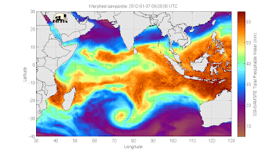
I'm the latest (last?) scientist contributor to this blog to arrive on Gan. I thought I might use one post to give my two cents on the resurrected/reborn debate. It's certainly something that we at S-PolKa have been talking a lot about over the past few weeks. If you look closely at the Hovmoeller diagram that Adam posted a few days ago, you could convince yourself that there is a slight bit of blue slanting up and to the right, connecting the latest MJO with the previous event. If this were a true connection it would imply that the previous MJO had stalled then propagated westward (from the fringe of phase 5 back into phase 4), and finally changed course and began its normal eastward motion. I think the soundings from Gan tell a different story though. If you look at the buildup of moisture and westerly winds that marked the beginning of the most recent MJO, the moisture is clearly building in from the west. As the westerly winds get deeper, so does the moisture.
In my mind, if the previous MJO event was moving from east to west into our domain and restrengthening here, then the winds during the buildup of moisture should have had at least some easterly component. It doesn't make sense to me that the previous MJO feature could be propagating westward while simultaneously generating intensifying moist westerlies. Am I missing some dynamical piece of the MJO that would allow for this to happen? Granted, Gan (longitude ~73E) was on the far left fringe of the latest event, so our soundings may not have been representative of what was happening in the eastern portion of the basin, but to me this looks like a new event.
The downside of having something interesting to talk about is that we now have most definitely transitioned into the suppressed stage over Gan. The time-height plot of moisture and winds over the past month looks like this,
and the daily rainfall estimates from S-PolKa look like this:
With the exception of those three days at the end of 2011, we've now been precip free for the better part of two weeks. Our column-integrated total precipitatable water estimates have been hovering around 40 mm, certainly on the lower side of the low end for this part of the world.
Despite all this dry air limiting our radar to observing nothing but non-precipitating shallow clouds, there has been one benefit. The lack of moisture and pollution in the atmosphere has allowed for some of the bluest skies I've ever seen. Really pretty stuff. The sunsets aren't bad either.
Cheers,
Casey


Why the first two pictures that come from the same station with overlap dates shows different pattern on Rh and wind ?
ReplyDelete