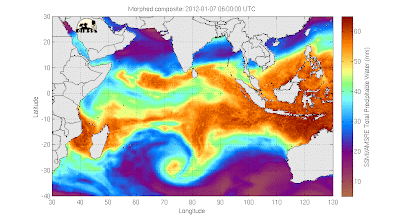
The basic sources of data for the upper air - above the surface of the earth - are radiosondes (aka weather balloons) and satellites. (There are some others, like measurements from commercial aircraft and ground-based remote sensors, but overall these are less important.)
Radiosondes are in some ways still the "best" source of data, because they provide true in situ measurements. That means one is sticking a probe into the actual system one wants to measure - the atmosphere - at the place one actually wants to measure it. Radiosondes provide measurements of temperature, humidity, wind, and pressure with (generally) high accuracy at all levels throughout the troposphere and into some of the stratosphere, if nothing goes wrong and causes the balloon to break prematurely. Over some regions at least - for example, the continental US - there are enough of them to define the horizontal structure of the flow pretty well. On the other hand, there are large regions of the earth - most of the oceans, many developing countries, Antarctica - where radiosonde launch sites are sparse to nonexistent. If sondes were all we had, we wouldn't know much about what the atmosphere were doing over these places at any given moment.
Satellites are great this way. They have a few different types of orbits (geostationary, polar orbiters...) but one way or another they survey large chunks of real estate on a regular basis. They don't care what the map beneath looks like (except inasmuch as the nature of the earth's surface may affect the measurements themselves, e.g., some instruments work better over ocean vs. land).
The down side of satellites, on the other hand, is that they are remote sensors. They don't make in situ measurements, which means that they don't directly measure the properties of the atmosphere. They measure properties of the radiation coming up to space, and infer from that some desired property of the atmosphere below - temperature, rainfall etc. This can only be done so well.
A particular limitation of satellites is their relative lack of vertical resolution - they can tell you what the temperature is (for example) but they can't tell you with perfect precision at what height is it that temperature. The radiation coming up from the atmosphere tends can in general have been emitted from more than one particular height in the atmosphere - nothing tags the photons to indicate precisely what altitude they came from. Two photons coming from different levels look the same as two coming from the same level. So to the extent that the properties of the photons carry information about the atmosphere, that information is mixed together from different levels. To get a feeling for this, here's an imperfect analogy: imagine dropping your keys into a swimming pool (or your other favorite body of water) and watching them as they fall straight down. How accurately do you think you could tell at any given point how deep they have gone?
There is a whole sophisticated science of remote sensing whose job it is to get around this problem, and due to both improvements in the physical instruments on the satellites and the "retrieval algorithms" (mathematical methods used to turn the measurements of radiation into temperature etc.) it gets better all the time. But satellites will probably never truly be able to beat radiosondes at their own game, which is high-resolution vertical profiles of atmospheric variables at a single horizontal location. They don't have to, though; to the extent that we have both types of measurements, we can use each one to compensate for the weakness of the others.


